
The Basant Panchami marks the beginning of spring in India. It is a new beginning as the harsh cold weather starts to subside and folks get to spend more time outdoors working and farmers also nears the harvest season. In the North, it is that time of the year when mustard crops are harvested while in the South, rice harvesting begins in late January. Basant Panchami usually marks the beginning of the harvest season in various parts of the country.
Weatherwise changes are visible as the southern peninsula and eastern parts of India start to warm up transition towards the pleasant spring. Meanwhile, states in North and Central India will keep up with the wintery weather for another fortnight just before the pleasant weather starts in mid-February.
Winters this year have arrived late, also the Western Disturbances have been quite delayed, over the past week an active western disturbance caused heavy to very heavy snowfall over Kashmir, Ladakh and Himachal Pradesh. Towns in the region are buried in 2-3 feet of fresh snowfall.
During the period of 24-25 January, Gulmarg the most famous hill station in Kashmir recorded 86cm of fresh snowfall in the span of 48 hours on the other hand Koksar in Lahaul recorded a massive 71cm nearly 2.3 feet of fresh snowfall in the span of 24 hours on 25 January.
While continuing its record spree Dharamshala received 68.0mm in 24 hours till 25 January, setting the record of highest single day rainfall in the month of January after 1997.
Previous single day highest records are:
69.1mm on 20 January 1997
78.8mm on 31 January 1975
85.2mm on 26th January 1970
Meanwhile, the all time record of Dharamshala is 99.1mm from 5 January 1982.
Heavy rains and snowfall lashes parts of Himachal Pradesh on 25 January:
Rainfall:
Dehra Gopipur (Kangra) 93.0mm
Salooni 92.0mm
Nagrota (Kangra) 90.0mm
Chamba 73.0mm
Guler 69.0mm
Snowfall:
Gondhla 50.5cm
Salooni 45.7cm
Kukumsheri 32.3cm
Bharmaur 30.0cm
Keylong 23.0cm
Hansa 23.0cm
During the period of 24-25 January light to moderate rains occurred in parts of Punjab, Haryana and Uttar Pradesh while Delhi NCR experienced cloudy skies but remained rain free.
Rainfall ending 8:30am on 25 January in stations of Punjab:
Garhshankar 47.5mm
Hoshiyarpur 44mm
Nurmahal 16mm
Balachar 14.5mm
Chandigarh 13.5mm
Fazilka 12mm
Ropar 9mm
Samana 6mm
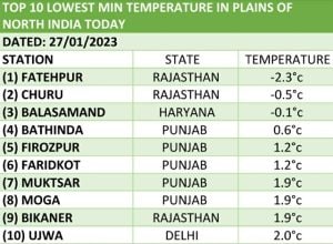
The western disturbance moved away on 26 January and skies opened up along with icy cold winds from the snow-clad mountains started blowing in plains of North India and night temperature’s have came down significantly, A temporary coldwave has hit parts of Punjab, Haryana and Rajasthan as temperature’s fallen to sub zero in Rajasthan’s Fatehpur registered -2.3°c, Churu -0.5°c and Balasamand in Haryana at -0.1°c on Friday morning, the impact of coldwave continued on Saturday morning too.
This is the second spell of “frost” that hit rural areas of Punjab, Haryana and Rajasthan in the month of January leading to damage to standing mustard crops.
National Capital Delhi recorded 5.8°c and 6.0°c minimum temperatures on 27 and 28 January.
The weather conditions are not as cold in other parts of the country. East India to be specific is reeling under unprecedented high temperatures in the past week under the influence of the anticyclonic circulation that leads to a hold of dry and warm air in the atmosphere.
On Friday, Kolkata recorded a maximum temperature of 29.0°c which is 3° above Normal while the minimum temperature on Saturday morning was 17.6°c registered 4° above the climatological normal.
Similarly, other parts of the east are seeing minimum and maximum temperatures by 3 to 7°c above normal. Ranchi recorded 15.0°c (5° above normal), Bhubaneswar 18.5°c (3° above normal), Jharsuguda 16.6°c (4° above normal) and Raipur 19.0°c (5° above normal) on Saturday morning.
Transition starts in southern India
Temperatures have started rising in Telangana, Andhra Pradesh, Karnataka while parts of Tamil Nadu and Kerala experienced rains in the mid week. Ending 8:30am on 25 January, Trivandrum recorded 53mm, Alappuzha 32mm, Kottayam 18mm, Kochi 16mm, Punalur 10mm, Valparai 30mm, Palakkad 3mm, Coonoor 3mm, Kozhikode 4mm, Mysore 21mm and Chikmagalur 10mm.
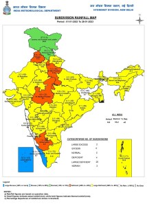
Despite good precipitation in North India in the past week pan-India winter rains continue to stay significantly below normal. The Country as a whole received 9.0mm rainfall against the normal of 15.2mm departure from normal stands at -41% in the period of 1 till 28 January.
Subdivision-wise seasonal rainfall in the period of 1 till 28 January, 2023:
• Southern Peninsula: Actual 2.1mm against the average of 7.3mm, -71% departure from normal.
• East & North East India: Actual 1.9mm against the average of 14.8mm, -87% departure from normal.
• North West India: Actual 25.7mm against the average of 30.1mm, -15% departure from normal.
• Central India: Actual 1.2mm against the average of 6.4mm, -82% departure from normal.
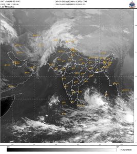
Current Synoptic features influencing weather in India as of 28 January, 2023:
• The Western Disturbance as a trough in middle tropospheric westerlies with its axis at 5.8 km above mean sea level now runs roughly along Long. 56°E to the north of Lat. 22°N.
• The low-pressure area over the Southeast Bay of Bengal & adjoining East Equatorial Indian Ocean with the associated cyclonic circulation extending upto middle tropospheric levels persists. It is very likely to move gradually west-northwestwards and become a well-marked low-pressure area during the next 24 hours.
Thereafter, it would continue to move west-northwestwards, intensify further into a depression around 31 January over the southwest Bay of Bengal and reach near the Sri Lanka coast around 1 February.
All India weather forecast till 4th February:
North India
January is about to end on a rainy note in the northern states of the country, a fresh active western disturbance is to impact most parts of the western Himalayas and plains of North West India from 29th January along with that a cyclonic circulation will form over central parts of Rajasthan helping in moisture incursion from Arabian sea towards North India.
Under the influence of the combination of weather systems, a fresh round of moderate to heavy snowfall is expected across Kashmir, Ladakh, Himachal Pradesh and Uttarakhand during 29-31 January. Parts of Shivalik ranges in the states to experience moderate rainfall.
Light to moderate rains are expected in many parts of Rajasthan on 29th January, Haryana, Punjab, Chandigarh Delhi NCR and Uttar Pradesh on 29th and 30th January. Thunderstorms and isolated Hailstorms may occur in some of the plains during this spell.
The minimum temperature is all set to increase in the region during the next three days and coldwave conditions will abate but cold wave onditions will be observed in stations of Punjab, Haryana, Rajasthan, Delhi and western Uttar Pradesh on the 29 and 30 of January.
Expected rainfall accumulation in the states of North India till 4 February:
• Jammu Kashmir and Ladakh: 70mm
• Uttarakhand: 60mm
• Himachal Pradesh: 60mm
• Punjab: 50mm
• Haryana 40mm
• Rajasthan: 30mm
• Delhi NCR: 20mm
• Uttar Pradesh: 20mm
Central India
The weather conditions won’t be as cold in the region as temperature’s have seen rising this weekend, On Sunday and Monday under the influence of the western disturbance over northern India, wind instability is all set to develop in interiors of Gujarat, Madhya Pradesh and Chhattisgarh, under such circumstances light to moderate rains and thunderstorms pop-up over the region.
Scattered light to moderate rains along with isolated hailstorms may occur in Gujarat, Madhya Pradesh and Chhattisgarh during 29-30 January, minimum and maximum temperatures are expected to stay above normal in the region during the upcoming week.
Expected rainfall in the region till 4 February:
• Madhya Pradesh: 20mm
• Gujarat: 10mm
• Maharashtra: 1mm
• Chhattisgarh: 1mm<
East and North East India:
An anticyclonic circulation will continue to dominate the region, due the weather system dry and abnormally warm weather is expected in most parts of Bihar, Jharkhand, Odisha, West Bengal and states of North East India during the beginning of the week with minimum and maximum temperatures can be 2 to 5°c above normal.
By the weekend from 2 to 4 February, temperatures will once again fall. Northwest winds will be back in the region as the ridge is expected to weaken.
South India:
A very rare January end low-pressure area has formed in the south east Bay of Bengal while moving in the west direction it is expected to become well marked low pressure area by 29 January and intensify into a depression near the Sri Lanka coast on 31 January.
Under the influence of the upcoming weather system light to moderate rain is expected in many parts of Tamil Nadu including Chennai from 29 January till 2 February. Some parts in southern Tamil Nadu, South Kerala may experience moderate to heavy rains.
The wet spell may impact the ongoing harvest of the crops in rural Tamil Nadu.
Most parts of Telangana, Andhra Pradesh, Karnataka, Goa will continue to experience dry weather conditions with slight rise in temperatures as we head into February.
Expected rainfall in the region till 4 February:
• Tamil Nadu: 40mm
• Kerala: 20mm
• Andhra Pradesh: 5mm
The author, better known as the Rohtak Weatherman, interprets and explains complex weather patterns. His impact-based forecasts @navdeepdahiya55 are very popular in north India.
Read all the Latest News, Trending News, Cricket News, Bollywood News,
India News and Entertainment News here. Follow us on Facebook, Twitter and Instagram.
from Firstpost India Latest News https://ift.tt/6EOlAx5
Comments
Post a Comment